The right way for every project
PROJECT-BASED
Are you planning to use personalized content for the first time? Are you working on a large or unusual project? Whether simple or complex, one-time or regular – we offer you the right implementation and easy handling.
locr BATCH TOOL
Do you want to create map projects on a regular basis? Use our web-based locr BATCH tool to create maps on our server and download them directly for your projects.
API
Do you offer software solutions or online services and want to generate maps in your application automatically? Our REST API gives you access to our map-on-demand service – for around-the-clock map generation via our server.
The right way for every project
Our cloud-based map servers have been fully integrated into software platforms or are available through partner programs with Variable Data Print (VDP) suppliers such as GMC, XMPie, and Pageflex.
Not sure which solution is best for you? Send us an email or give us a call, and we’ll be happy to advise you!
-
Create maps yourself with our online locr BATCH tool
-
Work with one of our partner platforms
-
Create an automated solution with our API: Here, you can find the API documentation
-
Or let locr manage your project
TECHNOLOGIES
Behind The Scenes
OPENSTREETMAP
We use data from OpenStreetMap, which provides comprehensive geographic coverage down to street level. The OpenStreetMap dataset has over 25 million kilometers of carefully surveyed roads and a wide range of geographic features that countless volunteers continuously update. Because it is open-source data that we turn into visually appealing maps, it is available under a clear license agreement.
SECURITY
locr uses secure FTP servers to enable the download of encrypted maps and data for our customers. We only accept encrypted or password-secured customer data files. This data is stored securely and automatically deleted two weeks after a project is completed. The cloud-based servers that locr uses are hosted in Germany.
MAP CREATION
locr MAPS are provided in the highest print quality of 300 – 1200 dpi, optimized for online use or as animated maps for videos. Using cloud-based server resources, our system can be used dynamically for high volumes of maps required at short notice. In print quality, the maps are issued as JPEGs and with assigned recipient IDs.
ICONS
Here you can find an overview of the icons we provide. These can be colored as desired in the full RGB color space. We will be happy to add your desired icon to your project.
For the complete list, please move the mouse over the icon window and scroll down or click here.

FAQ
Our maps are customized for your marketing campaign to show only the locations and information that are relevant to your customers. Factors such as the detailed map section, route, distance, and path are calculated individually for each recipient. Visual elements of the maps are also matched to your campaign design.
locr has always worked in compliance with the Datenschutz-Grundverordnung (DSGVO) to provide a high level of security, including:
- Anonymization of each customer address with the help of individual IDs
- Acceptance of encrypted data only
- Storage of data in secure servers
- Download of all maps and enriched customer data from secure FTP servers
- Deletion of data from our servers no later than two weeks after the completion of a project
You can be sure that the data you provide us with will be handled with the utmost care and attention to security.
Yes – always. Our maps are based on open-source data from OpenStreetMap under a clear license agreement. Therefore, the copyright sign cannot be removed.
To prepare maps for your marketing campaign, you’ll need to provide:
- Address lists as CSV or Excel files
- Recipient addresses, locations for LOCALmaps and target locations for NAVImaps each in separate files
- House number, street, city, postal code and country in separate fields
- individual ID per address in separate field (name of the later map image – can be added by us if necessary)
If you have multiple locations, but only want to show the recipient only the location closest to him, we can calculate this automatically for you. In addition, you can also specify a target location for each recipient. We will be happy to show you how this works!
We deliver the maps in JPEG format. The files are delivered as ZIP files with a maximum size of 2 GB. They are provided to you either via an HTTPS download link or via SFTP server.
Each map has its own name, which contains the recipient ID from your address file. We send you back the data file with the recipient ID and all GEOservices you requested.
The locr MAPS can now be dynamically integrated into your print production, e-mail or web pages. If you are working with a marketing service provider, they will know what to do. We are are avaialbe toprovide additional technical support to ensure that your project with the locr MAPS is a complete success!
In the locr BATCH tool you can generate maps up to A5 size. On a project basis, maps are available up to size A0. Do you need maps in a particularly large or unusual size? No problem – contact us!
The size and design of your maps are determined in advance. We create sample maps in advance so you can choose icons and visuals accordingly. This process provides you with customized maps that perfectly fit your project.
Since our maps are delivered in JPEG format, subsequent editing is not possible.
We specialize in the creation of personalized maps and geomarketing services, so we can support you in the graphic adaptation of maps as part of your project. We deliver these to your marketing department or to the service provider you trust.
For over ten years, we have successfully cooperated with hundreds of printers and design agencies. We are happy to recommend the most suitable partners for your project.
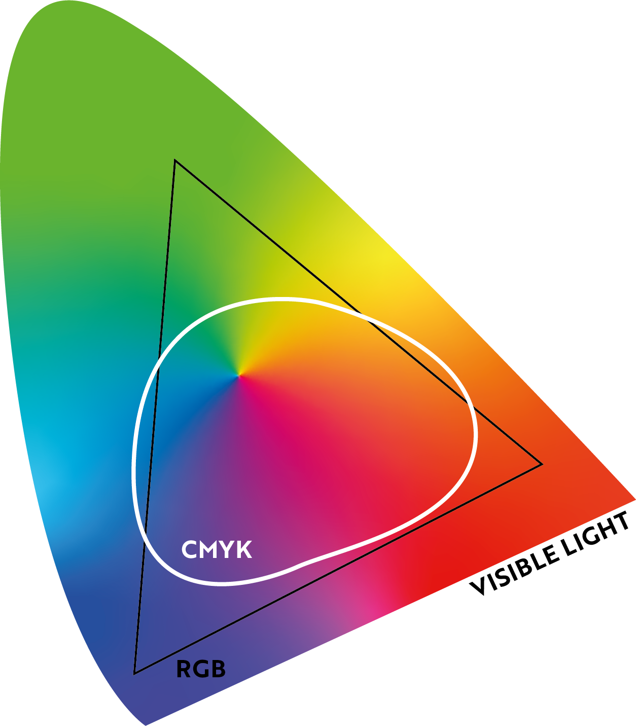
As shown in the image on the right RGB has an overall larger gamut
compared to CMYK. locr MAPS are created in RGB format.
For the best possible color and quality outcome it is best to have the pre-press apply the right color profile for the used press.
Your pre-press will want to apply their own color management to the RGB to produce their own CMYK and make sure it fits your requirements.
If you have different print engine technologies on your shop floor, you will get the best print results by either applying your own color management for your device, or letting the RIP of the print engine prepare the CMYK for that specific press.
CONTACT
*marks required field
We will not share your contact information or personal data with any third parties. For further information please see our privacy policy.
